An analysis of the damage to archaeological sites documented after a heavy rainfall event in July 2021 in parts of Germany shows that several factors increase the risk of damage to archaeological sites due to heavy rainfall and flooding events. For example, the age of the site, the current utilization of the terrain or the respective slope inclination influence the risk. However, the development of damage cannot be predicted, as the processes involved are too complex: Customized solutions are required for future protective measures. This is one of the conclusions reached by an interdisciplinary team of researchers from the University of Cologne, the LVR Office for the Preservation of Archaeological Monuments in the Rhineland (LVR-ABR) and RWTH Aachen University. The results are presented under the title ‘Assessing the impact of the 2021 flood event on the archaeological heritage of the Rhineland (Germany)’ in the journal Environmental Sciences Europe.
In addition to the question of whether damage to archaeological sites caused by heavy rainfall and flooding can be predicted, the researchers wanted to find out whether and how such damage can be assessed more quickly in the future. The study was based on data collected from 2022 to 2023 in areas of the areas Eifel, Voreifel and Bergisches Land as part of the LVR-ABR’s ‘Flood damage cadastre 2021’ project (Schadenskataster Hochwasser 2021, funded by the Ministry of Regional Identity, Local Government, Building and Digitalization of the State of North Rhine-Westphalia). The heavy rainfall and flooding event on 14 and 15 July 2021 had catastrophic consequences for people, nature and infrastructure that continue to have an impact to this day. Archaeological sites, such as parts of former hydropower plants, were also affected.
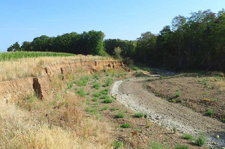
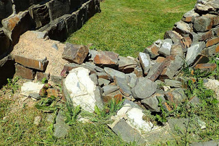
The project examined 538 archaeological sites in flood-prone areas for damage. The analysis of the data shows that 19 per cent of the investigated sites exhibited flood damage. Most of the damaged sites are more recent and are related to the use of hydropower in the Middle Ages and modern times. The damage was mainly caused by erosion, floating debris or washouts in the foundations and masonry. The relevant damage data and recommendations were sent to the respective municipalities; these reports can serve as a basis for applying for aid funds for reconstruction and protective measures.
An essential part of the published study involves analysing which factors increased the risk of damage to the sites. The team used statistical methods to test the archaeological and newly generated geographical data for correlations between the damage and individual or multiple factors. This showed that individual factors correlate statistically with the occurrence of damage, such as the age of the site, the current utilization of the terrain or the prevailing slope inclination. However, a combination of meaningful parameters would be necessary for a reliable prediction of cases of damage, for example in areas that have not yet been investigated or affected. The analysis which included several factors showed that although the regional topography plays a very important role in the occurrence of damage, the causes of damage across the area under investigation were so complex that it was not possible to derive such a set of parameters. Still, the results provided indications that larger samples from topographically more uniform areas or a focus on individual, particularly frequently affected ground monument types could provide further insights. Researchers from RWTH Aachen University also see potential in integrating hydrological modelling of individual river situations to improve the prediction of damage to ground monuments in the future.
Another aspect of the study is dedicated to the potential of airborne laser scanning (ALS) data for detecting flood damage. The elevation data of the ground surface before and after the flood event are compared in order to identify changes. This methodological approach, which has already been tried and tested at other sites, has clear advantages in areas that are difficult to access. However, this method cannot replace extensive and often time-consuming field work on site. This is because the ALS method does not allow, for example, the identification of very minor damage or damage repaired shortly after the flood event. Only around fifty per cent of the cases of damage observed in the study can be identified using the remote sensing method employed here, which is based on the ALS data from the national survey.
“The results of the project illustrate both the advantages and potential as well as the limits of geostatistical data analysis and the use of ALS data in the context of heavy rainfall and flood disasters,” said Dr Isabell Schmidt from the University of Cologne. “In particular, the diversity of archaeological sites and the variety of natural conditions in the Rhineland pose a challenge for the development of uniform damage forecasts and guidelines for the protection of archaeological sites.” According to the researchers, the empirical data obtained is nevertheless suitable for deciding on individual protective measures on site. In view of climate change and potentially more frequent heavy rainfall events, this information will be important for the development of prevention and disaster protection plans.
Media Contact:
Dr. Isabell Schmidt
Department of Prehistoric Archaeology of the University of Cologne
isabell.schmidt![]() uni-koeln.de
uni-koeln.de
Claudia Koppmann
LVR Office for the Preservation of Archaeological Monuments in the Rhineland
Claudia.koppmann![]() lvr.de
lvr.de
Press and Communications Team:
Eva Schissler
+49 221 470 4030
e.schissler![]() verw.uni-koeln.de
verw.uni-koeln.de